

Ever tried capturing cool landscape pictures only to end up with mediocre results? That perfect mountain vista or stunning sunset never quite looks as magical on your screen as it did in person.
Technology has dramatically transformed landscape photography over the past few years. What once required expensive equipment, perfect timing, and years of experience can now be achieved with the right apps and a decent smartphone. These specialized tools help photographers plan shots, find ideal locations, monitor weather conditions, and edit images to professional standards.
The challenge no longer lies in equipment limitations but in knowing which apps actually deliver results. From planning tools that predict golden hour to editing software that enhances natural colors without making them look artificial, the right app can make all the difference.
This comprehensive guide walks you through the 15 best apps for capturing breathtaking landscape pictures in 2025. Whether you’re hunting for the perfect mountain reflection, chasing dramatic storm clouds, or simply wanting to document your outdoor adventures more effectively, these apps will significantly elevate your photography game.
PhotoPills
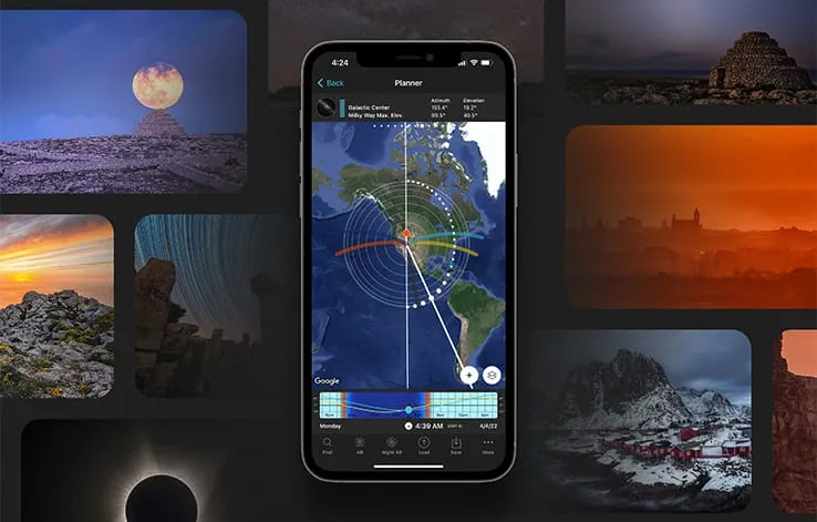
PhotoPills stands as the ultimate “Swiss Army knife” for landscape photographers seeking to capture impressive shots. This powerful planning tool helps you be at the right place at the right time for those perfect landscape moments.
PhotoPills key features
PhotoPills includes 16 photography modules designed to solve specific photography challenges. The heart of the app is the Planner tool, which shows precisely when and where the sun, moon, and Milky Way will appear from any location. Furthermore, its augmented reality feature allows you to visualize celestial paths directly through your phone’s camera. Additional tools include exposure calculators, depth of field calculators, and specialized modules for star trails, time-lapses, and hyperfocal distance.
PhotoPills pros and cons
Pros:
- Comprehensive all-in-one planning solution
- Works offline after caching map areas
- Intuitive interface despite numerous features
- Extensive educational resources and community
Cons:
- Steeper learning curve for beginners
- Not available for M1/M2 computers
- Works only in portrait mode on smartphones
PhotoPills pricing
PhotoPills costs CAD 15.31 for both iOS and Android devices. Although higher priced than many apps, it replaces numerous individual tools that would cost over CAD 69.67 if purchased separately.
PhotoPills best use case
PhotoPills excels when planning landscape shots involving celestial elements—particularly sunrise/sunset alignments, moonrise/moonset positioning, and Milky Way photography. Essentially, it’s ideal for photographers who want to plan unique landscape compositions in advance rather than relying on luck.
The Photographer’s Ephemeris 3D
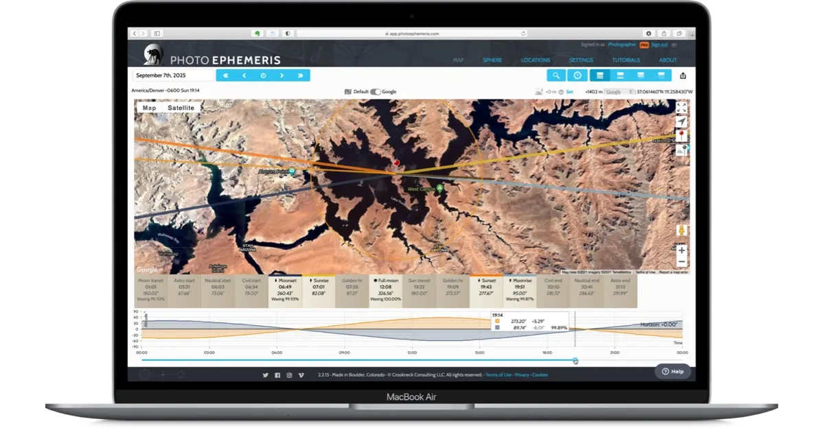
While many apps show you light conditions, The Photographer’s Ephemeris 3D (TPE 3D) brings landscape photography planning into the future with immersive terrain visualization. This app allows photographers to virtually “step into” locations before arriving on site.
The Photographer’s Ephemeris 3D key features
TPE 3D offers photorealistic 3D simulations of any landscape worldwide, letting you visualize precisely how light will interact with terrain features. You can scrub through time to see exactly how shadows fall across mountains, valleys, and other landscape elements. The app shows detailed sun and moon positions relative to the landscape and provides augmented reality visualization for on-location planning. Moreover, you can save favorite locations and planned shots for easy reference.
The Photographer’s Ephemeris 3D pros and cons
Pros:
- Realistic 3D visualization of landscapes and light conditions
- Accurate shadow prediction across complex terrain
- Intuitive time controls for planning golden hour shots
- Integration with regular TPE app
Cons:
- Higher learning curve than simpler planning apps
- Requires more device processing power
- iOS only (no Android version available)
- Limited offline functionality
The Photographer’s Ephemeris 3D pricing
TPE 3D operates on a one-time purchase model at $8.99, making it relatively affordable compared to subscription-based alternatives. The standard TPE app costs $3.99 and is often purchased alongside the 3D version for comprehensive planning.
The Photographer’s Ephemeris 3D best use case
TPE 3D excels for photographers shooting in mountainous regions where terrain significantly impacts lighting. It’s especially valuable when planning cool landscape pictures that depend on specific shadow patterns or when scouting unfamiliar locations remotely before traveling.
Sun Surveyor
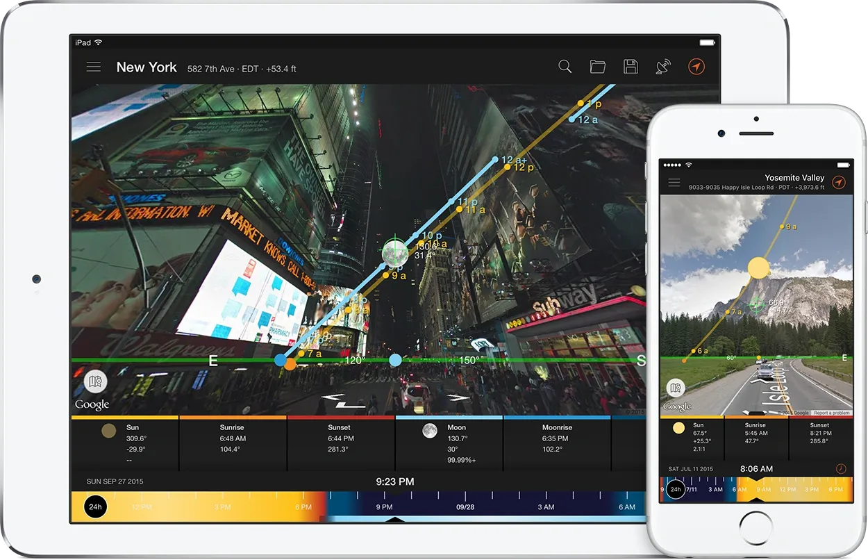
Sun Surveyor transforms your device into a powerful sun and moon positioning tool through its innovative augmented reality features. For photographers seeking cool landscape pictures with perfect lighting, this app removes much of the guesswork.
Sun Surveyor key features
Sun Surveyor’s standout feature is its augmented reality Live Camera View that projects sun and moon paths directly onto your screen. The Interactive Map provides a top-down perspective of celestial paths, meanwhile the detailed Ephemeris offers comprehensive data about sunrise, sunset, golden hour, and blue hour times. Additionally, the app includes specialized tools for night photography including Milky Way visualization and a Position Search tool to find optimal shooting times.
Sun Surveyor pros and cons
Pros:
- Comprehensive celestial positioning data with augmented reality visualization
- Works offline (except Map and Street View features)
- User-friendly interface despite extensive features
- One-time purchase instead of subscription
Cons:
- Not free (premium app pricing)
- Potentially overwhelming for casual users
- Some features vary between iOS and Android
- Occasional accuracy issues due to device hardware limitations
Sun Surveyor pricing
Sun Surveyor costs CAD 18.10 for iOS with similar one-time payment pricing for Android. A free “Lite” version with limited functionality is also available.
Sun Surveyor best use case
Sun Surveyor excels when planning landscape photography that depends on specific lighting conditions. The app is equally valuable for architecture visualization, solar panel positioning, gardening, and real estate work. Notably, the app allows photographers to predict exactly when light will hit landscape features at the perfect angle.
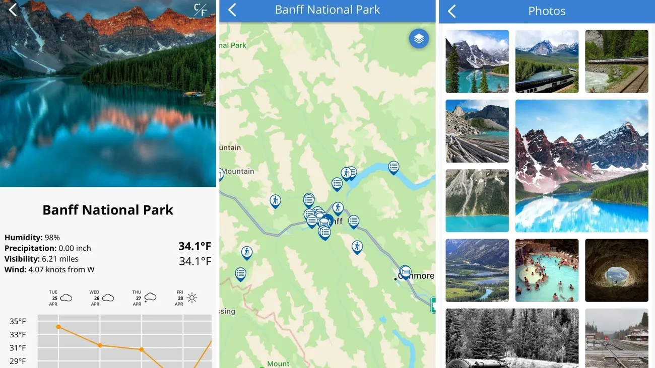
Weather & Radar
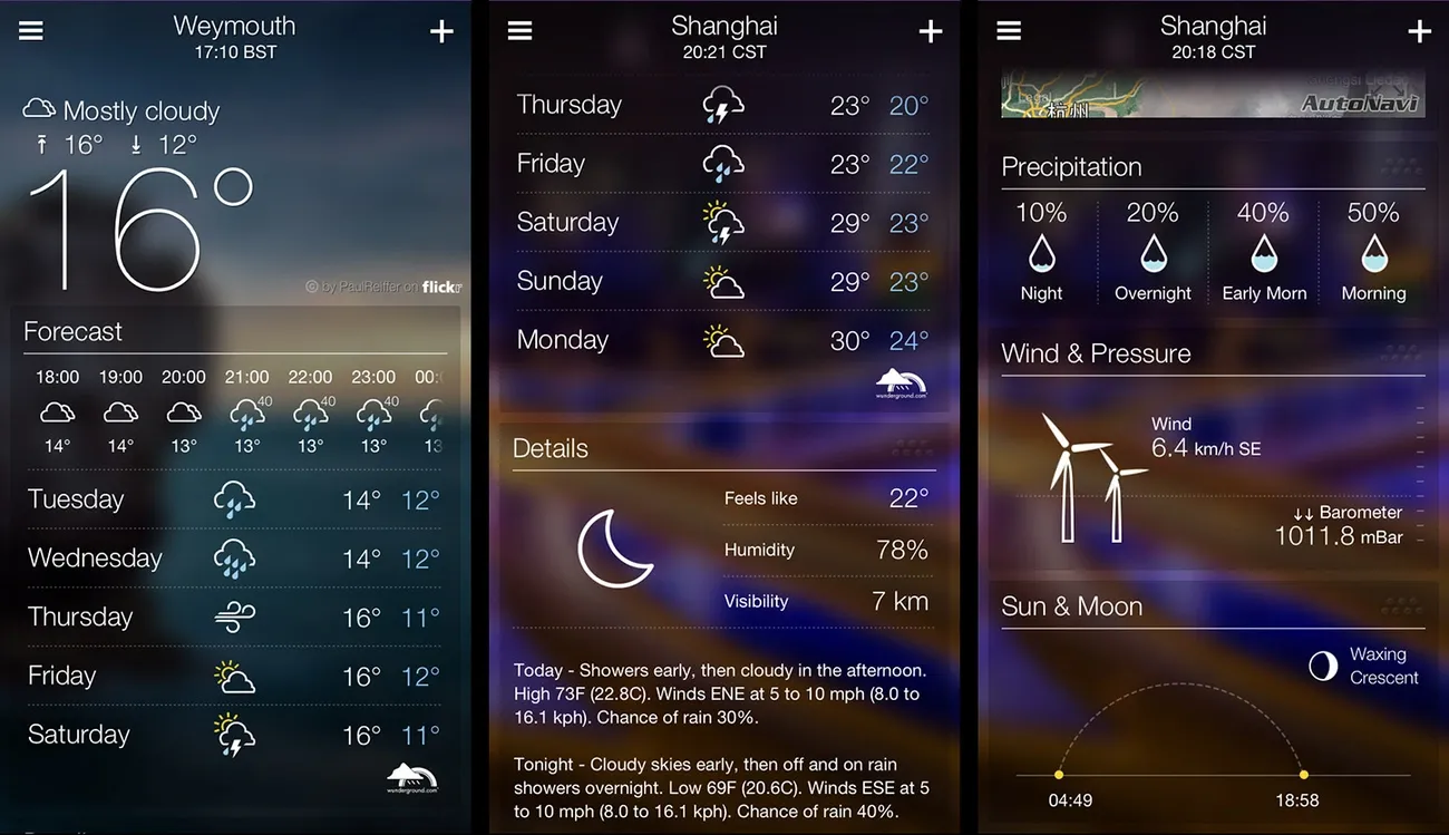
For landscape photographers, accurate weather forecasting can be the difference between capturing breathtaking images or coming home empty-handed. Weather & Radar delivers precise meteorological data specifically helpful for planning outdoor photography sessions.
Weather & Radar key features
Weather & Radar provides accurate hourly, daily, and longer-term weather forecasts with impressive precision [12]. Its interactive maps display rain, snow, ice, thunderstorms, lightning, wind patterns, and temperatures in real-time [12]. The app includes severe weather alerts and notifications about dangerous conditions in your area [12]. Additionally, Weather & Radar offers detailed information on cloud cover percentages, which proves invaluable when planning sunrise or sunset shoots.
Weather & Radar pros and cons
Pros:
- Precise radar tracking for rain, snow, and wind patterns in real-time
- Allows photographers to modify plans as weather shifts
- User-friendly interface with quick loading times
- Helpful widgets for at-a-glance weather updates
Cons:
- Free version contains numerous advertisements
- Potentially overwhelming interface for casual users
- Subscription required for ad-free experience
Weather & Radar pricing
The app offers a free version with advertisements. For an ad-free experience, Weather & Radar provides subscription options at CAD 2.08 monthly or CAD 16.01 annually.
Weather & Radar best use case
Weather & Radar excels for photographers capturing cool landscape pictures in erratic conditions. It’s particularly valuable when timing walks around rain, tracking approaching storms, or maximizing photographic experiences regardless of weather conditions. Consequently, many professionals pair it with other apps like Clear Outside for comprehensive weather planning.
Clear Outside
Originally designed for astronomers, Clear Outside has become a favorite among landscape photographers searching for perfect shooting conditions. This free app focuses primarily on detailed cloud forecasting with extraordinary precision.
Clear Outside key features
Clear Outside delivers seven-day hourly forecasts that update every hour. The app breaks down cloud cover by altitude – showing low, medium, high, and total cloud percentages. Beyond clouds, it provides astronomical data including moon phases, sunrise/sunset times, and darkness levels. Furthermore, it offers unique ISS pass-over information with precise timing calculations for your exact location. The interface uses intuitive color indicators (green, orange, red) that instantly show the best hours for photography.
Clear Outside pros and cons
Pros:
- Detailed cloud cover breakdown for predicting conditions for cool landscape pictures
- Free app with no required subscriptions
- Hourly updates that catch brief clear periods
- Light pollution information with Bortle scale ratings
Cons:
- Interface defaults to Exeter, Devon UK location
- Some users report occasional forecast inaccuracies
- Search function can be difficult for finding US locations
- Slightly dated interface that doesn’t fit newer iPhone screens
Clear Outside pricing
Clear Outside is completely free for both iOS and Android platforms.
Clear Outside best use case
Clear Outside shines when planning shots that depend on specific cloud conditions. In fact, it’s excellent for predicting clear nights for astrophotography or determining when partial clouds might create dramatic sunrises or sunsets. The app helps landscape photographers distinguish between high clouds (ideal for colorful sunsets) and fast-moving clouds (perfect for creating streaking effects).
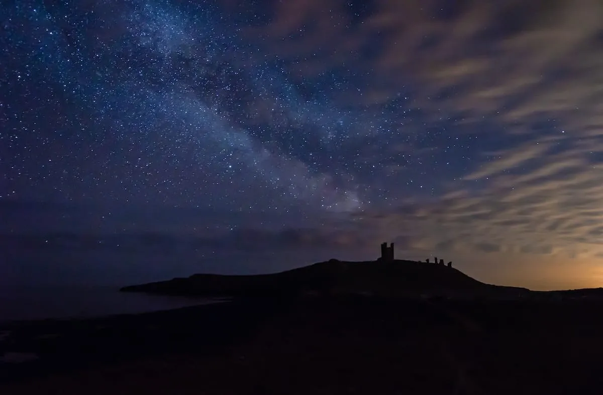
Light Pollution Map
Finding the darkest skies is crucial for capturing stellar landscape photography at night, and Light Pollution Map makes this process remarkably straightforward. This specialized app helps photographers locate areas with minimal light pollution for optimal star photography.
Light Pollution Map key features
Light Pollution Map displays detailed, color-coded visualization of light pollution levels worldwide. The app offers interactive maps showing VIIRS/World Atlas data alongside cloud cover overlay with adjustable opacity. First and foremost, it includes aurora borealis forecasting with live KP values and magnetic field information. Additionally, the app provides a night sky event calendar for tracking lunar eclipses, super moons, and meteor showers. Users can save favorite dark sky locations and receive customizable alerts for celestial events.
Light Pollution Map pros and cons
Pros:
- Highly accurate light pollution mapping to find optimal photography locations
- Works with various base maps including road and satellite views
- Includes detailed moon information and direction tools
- Offline functionality after initial map caching
Cons:
- Some features require pro version upgrade
- May not account for temporary light sources or real-time changes
- Cloud cover can affect accuracy of light pollution readings
- Not compatible with some newer Android phones
Light Pollution Map pricing
The iOS version costs CAD 6.95 as a one-time purchase. In contrast, the Android version offers a free option with in-app purchases or a premium upgrade at CAD 13.92.
Light Pollution Map best use case
Light Pollution Map excels for photographers seeking cool landscape pictures featuring the night sky or aurora. It helps identify areas with Bortle Scale 1-3 darkness ideal for Milky Way photography. Throughout your journey, it assists in finding locations sufficiently distant from city lights for capturing dramatic starscapes.
PeakVisor
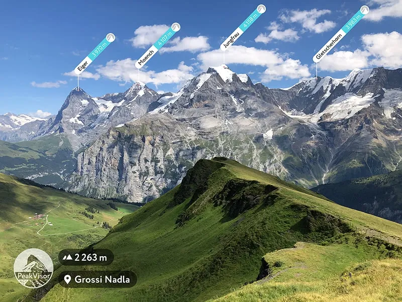
Mountain identification becomes effortless with PeakVisor, a specialized app that transforms how photographers capture and understand landscapes. Using augmented reality technology, this tool brings new dimension to landscape photography planning.
PeakVisor key features
PeakVisor’s core functionality centers on mountain identification, displaying names and elevations of peaks through your phone’s camera. The app offers detailed 3D maps with hiking trails, making it a precise navigation tool for outdoor adventures. First and foremost, PeakVisor works offline after downloading regional maps. The Sun Trail feature reflects sun movement, helping photographers understand the perfect time for capturing photos. Additionally, the Photo Import option allows users to import any image and overlay it with 3D landscape models to identify mountains in previously taken pictures.
PeakVisor pros and cons
Pros:
- Identifies over one million mountains worldwide
- Works offline with downloaded maps
- Provides 3D visualization of terrain
- Includes information about peaks, mountain huts, and hiking trails
Cons:
- Offline use requires Pro subscription
- Limited customer support options
- Requires substantial storage space for HD maps
- Primarily focused on natural features rather than structures
PeakVisor pricing
The app offers a 7-day free trial. Starting June 2025, monthly subscriptions will cost CAD 13.92 (previously CAD 8.35), yearly subscriptions CAD 55.72 (previously CAD 41.79), and a new 3-year option at CAD 139.34. A lifetime gift version is available for CAD 209.00.
PeakVisor best use case
PeakVisor excels for photographers capturing cool landscape pictures in mountainous regions. Hence, it’s invaluable when exploring unfamiliar areas and identifying distant peaks. The app proves particularly useful for creating augmented reality postcards with labeled mountains, helping viewers understand what they’re seeing.
Long Exposure Calculator
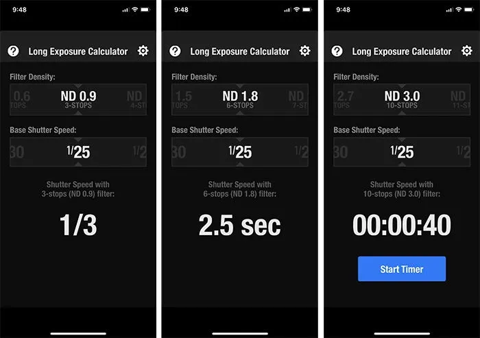
Taking stunning long exposure shots requires precise calculations, especially when using ND filters. Long Exposure Calculator simplifies this process for photographers seeking to capture cool landscape pictures with silky water or cloud movement effects.
Long Exposure Calculator key features
Long Exposure Calculator determines the correct exposure time when using Neutral Density filters. The app supports up to 24-stops of ND filter strength and includes a countdown timer for exposures exceeding 10 seconds. Typically, it works by inputting your base shutter speed and filter strength, then the app calculates the required exposure time automatically. The interface is straightforward with simple sliders for quick adjustments.
Long Exposure Calculator pros and cons
Pros:
- Extremely simple and intuitive interface
- No advertisements despite being free
- Functions offline without internet connection
- Compatible with iPhone, iPad, and iPod touch
Cons:
- Lacks an alarm feature at the end of the timer countdown
- Only displays full stop shutter speeds in some versions
- No aperture settings in some versions
- Limited to ND filter calculations only
Long Exposure Calculator pricing
Long Exposure Calculator is completely free, unlike many competitors that charge subscription fees. Firstly, this makes it accessible to photographers at all levels without financial commitment.
Long Exposure Calculator best use case
This app shines for daytime long exposures when capturing flowing water, moving clouds, or busy streets. Throughout a shooting session, photographers can quickly adjust settings as light conditions change. Simply take a test shot without filters, input that shutter speed, select your ND filter strength, and the app does the rest.
Cascable
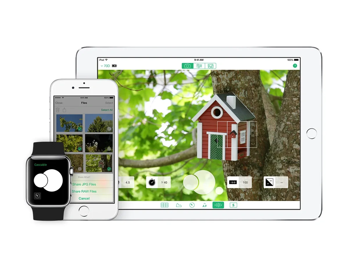
Cascable turns your mobile device into a powerful remote control hub for your camera, offering advanced capabilities for photographers shooting in remote locations.
Cascable key features
Cascable provides full camera control through WiFi or USB connections, compatible with over 200 different camera models from major manufacturers. The app includes automation tools for timelapses, exposure bracketing, and complex shooting sequences. Through its Shutter Robot Recipes feature, photographers can create detailed, customized shooting sequences. Furthermore, Cascable offers RAW file support for viewing and transferring high-quality images directly to your device.
Cascable pros and cons
Pros:
- Unified interface regardless of camera brand
- Works with both WiFi and USB connections
- Powerful drag-and-drop automation for complex sequences
- Focus peaking to help achieve perfect sharpness
Cons:
- Occasional connection issues requiring reconnection
- Some features vary by camera model
- Pro features require additional purchase
- Learning curve for advanced automation features
Cascable pricing
Cascable offers two purchase options: a one-time payment of CAD 41.80 or subscription plans starting at CAD 2.79 monthly (billed quarterly). The app is available free with limited functionality.
Cascable best use case
Primarily ideal for landscape photographers capturing cool landscape pictures from difficult angles or when precise camera positioning is critical. Above all, it excels in automated sequences like sunrise/sunset timelapses where changing conditions require programmed exposure adjustments.
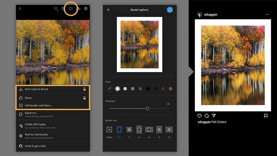
VSCO

VSCO serves as a powerful editing companion for those who have already captured cool landscape pictures and now want to enhance them. This mobile app transforms ordinary landscape shots into artistic masterpieces through specialized filters and editing tools.
VSCO key features
VSCO offers a dedicated Landscape Series of presets (L1-L12) specifically designed for natural scenery including mountains, valleys, forests, beaches, coasts, and deserts. The app provides 200+ photo filters powered by cutting-edge technology, coupled with comprehensive editing tools like exposure adjustment, contrast enhancement, and HSL controls. Moreover, VSCO allows users to save favorite edits as “Recipes” for consistent editing across landscape collections.
VSCO pros and cons
Pros:
- Specialized landscape presets that enhance natural beauty
- Powerful yet intuitive editing tools
- Ability to save editing recipes for consistent style
- Community platform for inspiration
Cons:
- Limited features in free version (only 15 presets)
- Full functionality requires subscription
- No dedicated planning tools for landscape shoots
- Interface can be confusing for beginners
VSCO pricing
VSCO offers three tiers: Starter (free with 15 presets), Plus (CAD 3.48/month annually or CAD 11.13/month) with 200+ presets and video editing, and Pro (CAD 6.97/month annually) adding desktop editing and Adobe Lightroom integration.
VSCO best use case
Ultimately, VSCO excels at post-processing landscape images with film-inspired esthetics, making it ideal for photographers who want to create cohesive landscape portfolios with consistent visual style.
Adobe Lightroom Mobile
Adobe Lightroom Mobile brings professional-level editing power to your fingertips, turning ordinary snapshots into cool landscape pictures through its comprehensive toolset. This powerful app combines desktop-class editing capabilities with the convenience of mobile photography.
Lightroom Mobile key features
Lightroom Mobile offers an incredibly polished interface with tools organized by category including edit, presets, crop, masking, and lens blur. The Scene Enhance feature introduced in 2025 specifically targets landscape elements like mountains, water, ground, and sky. Subsequently, the masking tools allow selective adjustments to specific parts of an image without leaving the app. Apart from editing capabilities, Lightroom automatically syncs your photos across devices through cloud storage, enabling seamless workflow continuation between mobile and desktop.
Lightroom Mobile pros and cons
Pros:
- Clean, intuitive interface that’s quick to master
- Powerful selective adjustments for precise landscape editing
- Cloud syncing enables editing anywhere
- AI-powered features like generative remove
Cons:
- Limited features in free version
- Subscription required for premium features
- Interface can feel clunky when editing large batches
- Finding specific settings sometimes takes time
Lightroom Mobile pricing
The free version offers basic organization and editing tools. For premium features, options include the Photography Plan with Lightroom and 1TB storage for CAD 13.93 monthly or Lightroom with Photoshop and 20GB storage at the same price. Alternatively, various mobile-specific plans range from CAD 2.77 monthly for 40GB to CAD 13.92 monthly for 1TB.
Lightroom Mobile best use case
Lightroom Mobile excels when enhancing landscape photography on the go. It’s ideal for photographers who want to apply the Adobe Landscape profile to make colors stand out in natural scenery. Indeed, its ability to edit RAW files anywhere makes it perfect for field adjustments when capturing cool landscape pictures during travel.
Snapseed

Google’s Snapseed transforms ordinary photos into spectacular landscape masterpieces through its powerful yet intuitive editing tools. This popular photo editor combines professional capabilities with remarkable simplicity.
Snapseed key features
Snapseed offers 29 professional-grade tools and filters including Healing, Brush, Structure, and HDR Scape. The HDR Scape tool excels at bringing out details in landscape photos. Alongside standard adjustments like brightness and contrast, Snapseed includes RAW file support and specialized tools for landscape photographers like curves, selective adjustments, and perspective correction. Users can save editing combinations as “Looks” that can be shared via QR codes.
Snapseed pros and cons
Pros:
- Completely free without ads or hidden costs
- Professional-grade editing tools typically found in paid software
- Non-destructive editing with ability to revisit individual adjustments
- Works offline after initial download
Cons:
- Steeper learning curve for advanced features
- No desktop version available
- Save options can be confusing for beginners
- Limited batch processing capabilities
Snapseed pricing
Snapseed is entirely free for both iOS and Android with no premium tier or advertisements.
Snapseed best use case
Snapseed excels for enhancing landscape photography on the go. Therefore, it’s perfect for photographers who want professional results without complex desktop software. Its QR Look presets make editing landscape collections effortless and consistent.
AllTrails
For photographers seeking ideal shooting locations, AllTrails serves as an extensive database of trails and natural spots worth exploring. With over 450,000 curated trails worldwide [58], this platform helps photographers discover hidden gems for capturing remarkable landscape imagery.
AllTrails key features
AllTrails offers powerful search functionality with comprehensive filters for trail difficulty, length, elevation gain, and user ratings. The app provides detailed information about each trail including reviews from fellow hikers. Users can save favorite locations into organized lists for future reference. Leveraging data from millions of users, the premium version displays heatmaps showing popular routes.
AllTrails pros and cons
Pros:
- Extensive database with 450,000+ trails
- Active community providing real-time trail conditions
- Intuitive interface with excellent filtering system
- Offline maps with premium subscription
Cons:
- Offline functionality locked behind subscription
- Maps sometimes less detailed than specialized topographic alternatives
- Some user-generated content may be outdated
- Battery drain higher than simpler apps
AllTrails pricing
The free version offers basic trail information. AllTrails+ costs CAD 50.15 annually, whereas the new Peak tier (launched 2025) costs CAD 111.45 annually.
AllTrails best use case
Ideal for landscape photographers scouting locations off the beaten path, helping identify promising viewpoints through user-submitted photos.
Google Earth

Google Earth Pro goes beyond traditional mapping apps by offering virtual location scouting capabilities for landscape photographers. This free desktop application provides sophisticated 3D visualization tools ideal for planning the perfect shots.
Google Earth key features
Google Earth Pro enables 3D terrain visualization with ground-level views that simulate real landscapes. The Sun Tool shows precisely how light and shadows fall across terrain at different times of day. Users can record virtual tours of potential shooting locations and save them for future reference. The app includes measurement tools that help determine distances between shooting positions and subjects. Additionally, the Layers Panel allows toggling various elements like roads, weather, and 3D buildings.
Google Earth pros and cons
Pros:
- Completely free with no subscription required
- Photorealistic 3D rendering of landscapes and terrain
- Ability to visualize lighting conditions at specific dates and times
- Works as a preliminary research tool before physical visits
Cons:
- Navigation can occasionally be difficult to control
- Some areas have less detailed 3D mapping
- Cannot predict real-time conditions like weather
- Learning curve for advanced features
Google Earth pricing
Google Earth Pro is completely free to download and use. Conversely, Google Earth Engine, the cloud-based analysis platform, operates on a usage-based pricing model starting at CAD 696.68 monthly.
Google Earth best use case
Google Earth Pro excels at pre-visualizing landscape compositions prior to shooting. Photographers can virtually scout remote locations, understand terrain features, and plan precisely when light will create optimal conditions for cool landscape pictures.
Google Maps
Beyond desktop-focused tools, Google Maps provides landscape photographers with a mobile-friendly scouting solution. This ubiquitous tool serves as an unexpected ally for finding photogenic locations worldwide.
Google Maps key features
Google Maps offers aerial and satellite views for discovering potential shoot locations. The terrain-view feature displays topography, providing an almost 3D perspective of elevation changes critical for landscape composition. Street View lets photographers virtually explore locations before visiting, helping verify shooting possibilities. The app allows saving and labeling favorite locations for future reference.
Google Maps pros and cons
Pros:
- Ability to scout locations remotely before traveling
- Excellent terrain visualization for finding vantage points
- Easy location saving and labeling functionality
- Widely available across all devices with intuitive interface
Cons:
- Requires cellular reception for full functionality
- Cannot display real-time lighting conditions
- Limited offline capabilities compared to specialized apps
- Some areas have outdated imagery
Google Maps pricing
Google Maps offers a free tier for basic use with up to 10,000 calls per month. Advanced usage follows a pay-as-you-go model starting at CAD 9.75 per 1,000 map loads.
Google Maps best use case
Initially ideal for preliminary location scouting, typically helping photographers identify promising vantage points through aerial views. According to many professionals, it’s particularly valuable for planning urban landscape shots with precise positioning.
Conclusion
Landscape photography certainly transforms when equipped with the right digital tools. Throughout this guide, we’ve explored 15 exceptional apps that help photographers capture breathtaking landscapes in 2025. These apps collectively address every aspect of the photography process – from initial planning with PhotoPills and TPE 3D to weather tracking with Clear Outside, location scouting with AllTrails, and final editing with powerhouses like Lightroom Mobile and Snapseed.
Planning apps undoubtedly make the difference between average and extraordinary landscape shots. Apps like PhotoPills and Sun Surveyor predict precise lighting conditions, therefore eliminating guesswork when timing the perfect golden hour shot. Weather-focused tools such as Weather & Radar and Clear Outside allow photographers to anticipate ideal shooting conditions or dramatic storm clouds that add character to landscape compositions.
Location-specific apps additionally open new possibilities for discovery. Light Pollution Map guides photographers to pristine night skies, while PeakVisor identifies mountain ranges with remarkable accuracy. Google Earth and AllTrails lead adventurous photographers to hidden viewpoints off typical tourist paths.
Technical tools like Long Exposure Calculator and Cascable handle the precise calculations and remote control needs that once required expensive equipment. These specialized tools essentially democratize advanced techniques, making them accessible to photographers at all skill levels.
Editing apps ultimately complete the landscape photography journey. VSCO, Lightroom Mobile, and Snapseed each offer unique approaches to enhancing natural beauty without creating artificial-looking results. Their intuitive interfaces allow photographers to perfect their work anywhere, anytime.
The landscape photography experience has fundamentally changed thanks to these powerful apps. Amateur photographers can now achieve results previously possible only with years of experience and expensive gear. Professional photographers benefit from streamlined workflows and enhanced creative control. Regardless of your experience level, these 15 apps will significantly elevate your landscape photography in 2025 and beyond.
Your photography journey awaits – which app will you try first?