Did you know easy hikes Vancouver offers include hundreds of trails within a short drive of the city? These natural escapes are closer than you might think.
Surprisingly, some of the best hikes Vancouver has to offer are located less than 30-45 minutes from downtown, making them perfect for spontaneous weekend adventures. Whether you’re a local or visitor, these trails deliver stunning views without requiring extreme effort. In fact, most of these vancouver easy hikes have minimal elevation gain and can be completed in as little as 30 minutes to 3 hours. For instance, popular trails like Dog Mountain need just over an hour to complete with only 165 meters of elevation gain.
Ready to discover five secret spots that offer all the beauty without the challenge? These hidden gems provide the perfect balance of accessibility and natural wonder, all within a 1.5-hour drive from downtown Vancouver. Even better, many of these locations offer free activities that the whole family can enjoy, though they can get busy during summer weekends.
Hunter Trail, Mission
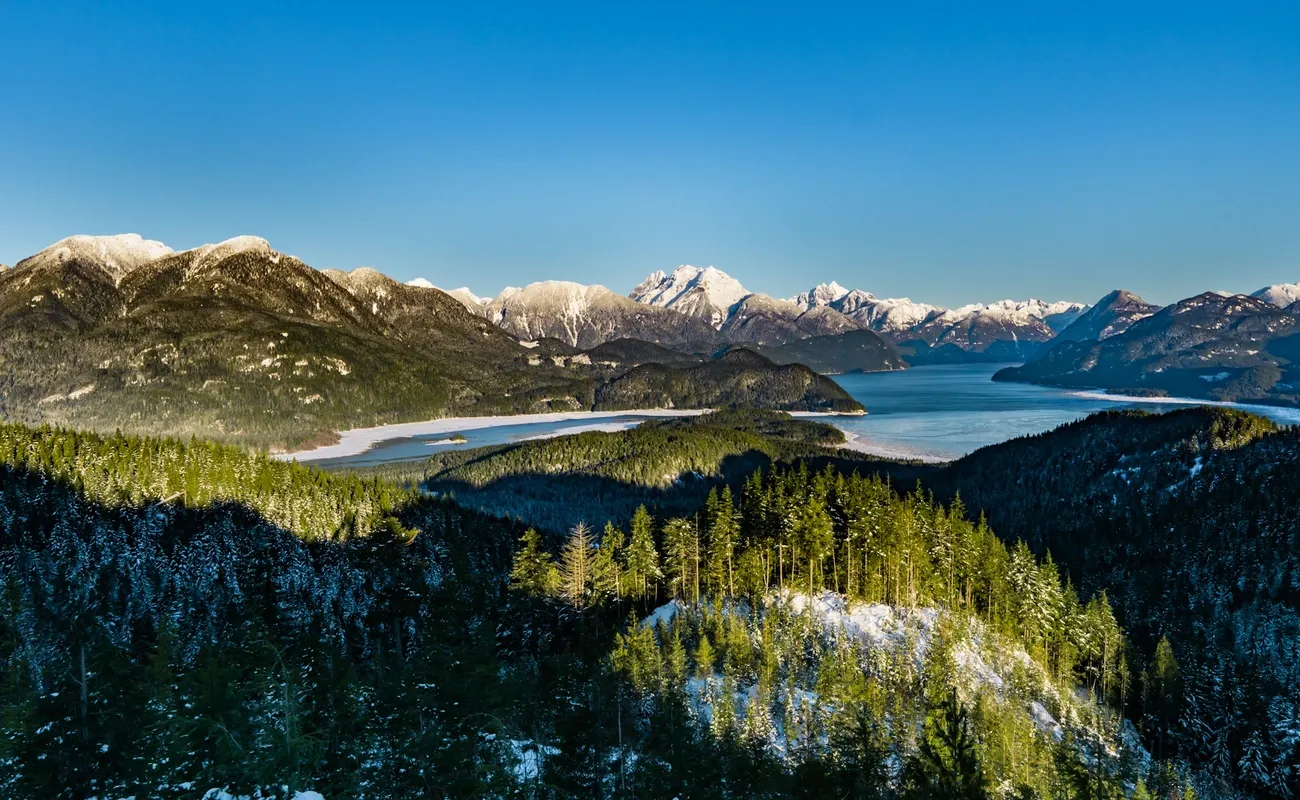
Image Source: Best Hikes BC
Located just over an hour’s drive from Vancouver, Hunter Trail stands as one of the best-kept secrets among the best hikes Vancouver has to offer. This hidden gem in Mission, BC rewards hikers with spectacular panoramic views while keeping the journey manageable for most skill levels.
Hunter Trail, Mission
Hunter Trail isn’t officially designated as a park—it’s actually an active forest service road that has gained popularity among hikers seeking less crowded alternatives to Vancouver easy hikes. Unlike many popular trails near the city, this path offers a unique combination of accessibility and stunning natural beauty without requiring extensive hiking experience.
Hunter Trail highlights
What makes Hunter Trail special is the breathtaking reward waiting at the end. The viewpoint offers spectacular, uninterrupted vistas of Stave Lake and the surrounding mountain ranges. On clear days, you’ll be treated to views of impressive peaks including Mount Judge Howay, Mount Robie Reid, Mount Crickmer, and Mount Saint Benedict.
The trail itself follows a wide gravel road the entire way, making it notably different from many other Vancouver easy hikes that feature narrow, root-filled paths. While the journey along the logging road might not be the most exciting part of your adventure, the spectacular views at the summit more than compensate for the straightforward terrain.
Additionally, there are two viewpoints accessible from the trail:
The first (and quickest to reach) provides an epic view of Stave Lake
With just 15 minutes more hiking, you’ll reach the second viewpoint with views of Mt. Baker
The trail is particularly beautiful if you visit when the surrounding mountains still have snow caps, creating a dramatic contrast against the blue waters of Stave Lake. Although the hike has grown in popularity through social media in recent years, it remains significantly less crowded than many trails closer to Vancouver.
Hunter Trail distance and elevation
Hunter Trail offers a moderately challenging trek with some variation in reported statistics:
Distance: 7.7-10 km round trip (approximately 8 km is most commonly cited)
Elevation gain: 230-334 meters
Average hiking time: 3-5 hours total[83]
The trail features an average gradient of just 7.44%, making it manageable for most hikers. Most of the elevation gain occurs in two sections—the first kilometer and the fourth kilometer—with the middle section being relatively flat. This distribution of effort allows for recovery periods between the more challenging stretches.
The beginning of the trail starts with a moderate climb up the gravel road for about 15 minutes before leveling out. After a middle section with minimal elevation gain, the final portion features another moderately steep climb that loops around the side of the hill before reaching the viewpoint.
Despite the elevation gain, the trail is considered easy to moderate difficulty because there are no technical aspects—it’s entirely on a wide, gravel forest service road. Importantly, there are three junctions along the route; to reach the viewpoint, go left at all three.
Hunter Trail dog-friendliness
Good news for pet owners looking for easy hikes Vancouver offers—Hunter Trail is fully dog-friendly. This makes it an excellent choice for a weekend adventure with your four-legged companion. The wide trail provides plenty of space for dogs to walk comfortably alongside you without navigating difficult terrain.
The trail has become especially popular among local dog owners. However, it’s important to keep your pet under control and leash them when approaching families with children. This courtesy ensures everyone can enjoy the trail safely and comfortably.
Given the trail’s length and exposure, remember to bring water for both yourself and your dog, particularly on warmer days. The gravel surface can be hard on sensitive paws during summer months, so consider this when planning your visit.
Hunter Trail parking and access
Finding the trailhead requires driving to Mission, BC, about 1.5 hours from downtown Vancouver. The parking area and trailhead are located at the end of Sabo Street in the Steelhead community of Mission.
A few key points about parking and access:
The gravel parking lot is extremely small, fitting only about 10 vehicles
No 4×4 vehicle is required as the road to the trailhead is paved
The parking coordinates are: 49.248262, -122.302728
Early arrival is strongly recommended, especially on weekends, as the lot fills quickly
Important warning: There is a sign at the parking lot stating that vehicles left after dusk will be towed. Furthermore, the District of Mission has installed “no parking” signs along Sabo Street and actively tows vehicles that ignore them. Plan your hike timing accordingly to avoid returning to find your car missing.
The trail begins at a yellow gate, which marks the entrance to the forest road. From there, follow the gravel road across a wooden bridge as it begins its upward journey. There are no facilities of any kind at the parking lot or anywhere along the trail, so come prepared with water and snacks.
Overall, Hunter Trail offers one of the most accessible Vancouver easy hikes with impressive rewards for minimal technical challenge. Its combination of manageable distance, straightforward terrain, and stunning views makes it an excellent choice for hikers of various skill levels seeking weekend adventures beyond the city’s most crowded trails.
Bowen Lookout
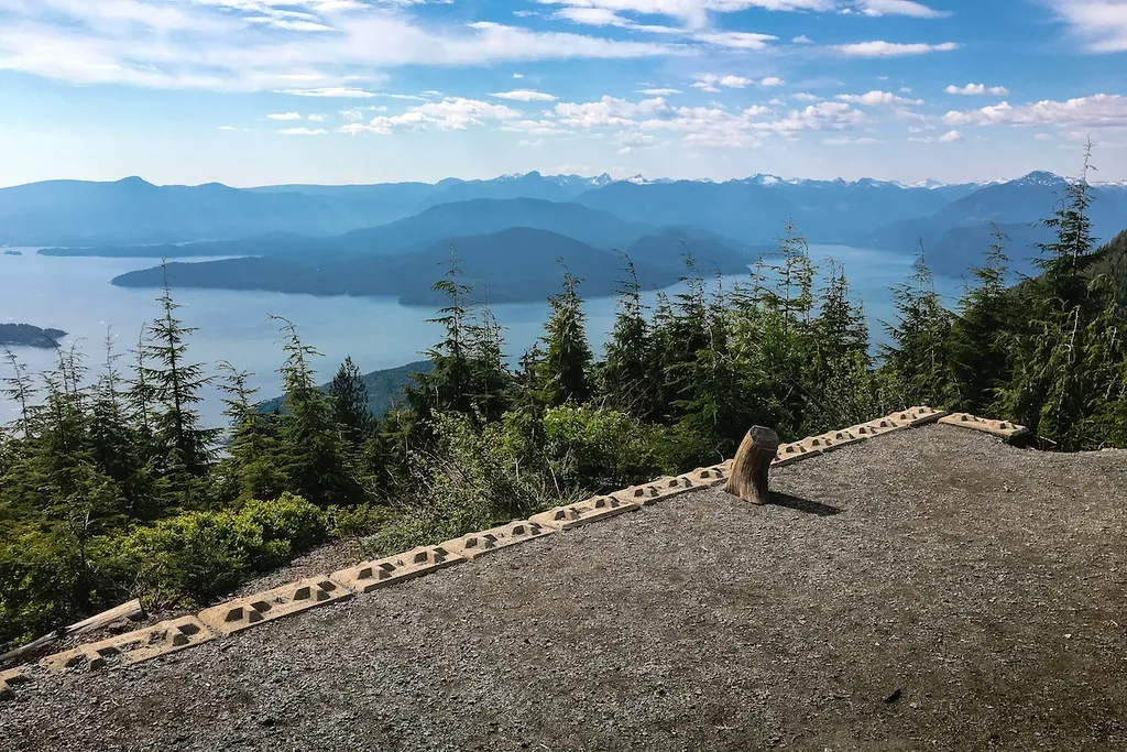
Image Source: Wander Vancouver
Bowen Lookout
Just 45 minutes from downtown, Bowen Lookout stands as one of the most accessible easy hikes Vancouver offers, situated in the beautiful Cypress Provincial Park. This short trail delivers remarkable value with its stunning panoramic views of Howe Sound and Bowen Island, making it a perfect choice for those seeking quick nature escapes.
Bowen Lookout trail features
The journey to Bowen Lookout takes you through diverse terrain that changes with each section of the trail. Initially, you’ll follow a well-maintained gravel path that winds through lush forest areas. As you continue, the trail meanders through serene meadows before returning to forest cover and beginning its gradual incline.
One of the most appealing aspects of this trail is its well-marked nature—clear signage directs hikers to Bowen Lookout at key junctions. Moreover, the path is relatively wide throughout most sections, making it suitable for groups hiking together without having to walk single file.
The final portion of the trail features the most significant elevation gain, but your efforts are generously rewarded. Upon reaching the lookout platform, you’ll be treated to breathtaking panoramic views that include:
The expansive Howe Sound stretching into the distance
Bowen Island directly across the water
Gambier Island and surrounding mountains
Vancouver’s cityscape on clear days
This vista point has become increasingly popular among photographers and nature enthusiasts seeking Instagram-worthy scenes without committing to longer, more challenging treks. Subsequently, the platform at the lookout provides ample space for enjoying a picnic or simply taking in the spectacular views.
The trail can be combined with the nearby Yew Lake loop for those wanting to extend their hike slightly. This addition offers a pleasant stroll alongside a lake and through marshland areas, adding minimal extra distance but providing variety to your hiking experience.
Bowen Lookout distance and elevation
Various sources report slightly different measurements for this trail, but the most reliable information indicates:
Total distance: 4 km round trip
Elevation gain: 110 meters [101]
Average completion time: 1.5 hours
The trail is generally rated as easy to moderate in difficulty. Whereas most of the path offers gentle gradients, there is one notable 500m section that becomes relatively steep with approximately 20% gradient. This steeper portion represents the primary challenge of the hike, as it climbs about 100m in elevation over this short distance.
The terrain primarily consists of fine gravel pathways with some dirt and roots. Certain sections, particularly those with loose gravel on steeper climbs, require a bit more caution. Nevertheless, the trail remains manageable for most fitness levels and hiking abilities.
In comparison to other Vancouver easy hikes, Bowen Lookout offers an exceptional view-to-effort ratio. You’ll gain significant visual rewards without the extensive time commitment or physical demands of longer trails. Consequently, it’s often recommended as an excellent starter hike for beginners or those pressed for time.
For winter hikers, it’s worth noting that during snowy periods, the trail becomes a popular snowshoe route. During these months, passage through the downhill ski area on the Backcountry Access Corridor requires a free BAC tag. These tags can be obtained at no cost from Cypress Mountain Resort at the Black Mountain Lodge “Backcountry Self Registration Area”.
Bowen Lookout best time to visit
Bowen Lookout is accessible year-round, each season offering a different experience on this versatile trail. The official hiking season typically runs from July through October, with summer months providing the most reliable weather conditions.
June through October represents the most popular period for visiting Bowen Lookout, when trails are generally clear of snow and visibility tends to be optimal for enjoying the panoramic views. Nonetheless, winter months transform this trail into a magical snowy landscape that’s equally worth experiencing.
For those seeking to avoid crowds, consider these timing strategies:
Winter visits are particularly special at Bowen Lookout. The trail becomes a popular snowshoe route, although many hikers find microspikes sufficient when the trail is well-packed. Winter hiking here offers the unique opportunity to experience snow in an avalanche-safe area.
Sunrise and sunset hikes to Bowen Lookout deserve special mention, as the lookout offers exceptional viewing conditions for these magical times of day. The golden light bathing Howe Sound creates extraordinary photography opportunities. Accordingly, if planning a sunset hike during summer months, ensure you park outside the main parking lot gates, as these close at sunset.
Early morning visits generally provide the most solitude, even during peak season. Furthermore, arriving early helps secure parking, which can become challenging during weekends and holidays.
It’s essential to note that during spring melting season, the trail can become very slippery due to ice and snow. For these conditions, bringing spikes for your boots is highly recommended to ensure safety and stability.
Dog owners will be pleased to learn that Bowen Lookout is dog-friendly, with pets allowed on the Howe Sound Crest Trail and the route to Bowen Lookout. The only restriction applies to the trail around Yew Lake, where dogs are not permitted. In all permitted areas, dogs must remain on leash at all times.
For those relying on public transportation, it’s important to note that Bowen Lookout is not accessible via public transit, making personal transportation necessary for this hike.
This trail’s combination of accessibility, modest physical requirements, and spectacular views makes it an ideal choice for visitors and locals alike seeking easy hikes Vancouver offers without compromising on scenic rewards. Its year-round accessibility furthermore ensures you can enjoy this trail regardless of when you visit the Vancouver area.
Pacific Spirit Park
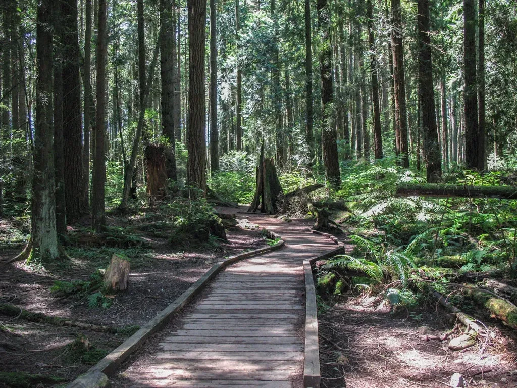
Image Source: Vancouver Trails
Pacific Spirit Park
Imagine stepping into a sprawling forest oasis within the city limits—Pacific Spirit Park offers precisely that experience among the easy hikes Vancouver features. Established in 1989 as a natural forest preserve, this 760-hectare green sanctuary creates a natural boundary between UBC and Vancouver proper, providing residents and visitors alike a chance to escape urban life without leaving the city.
Pacific Spirit Park trail network
The crown jewel of Pacific Spirit Park is its extensive trail system that winds through lush forest settings. With over 73 kilometers of trails, this network creates countless possibilities for exploration regardless of your experience level. The trails are divided into specific designations:
55.5 km of walking/hiking trails
34.4 km of cycling trails
37.1 km of horseback riding trails
Indeed, approximately 50 kilometers of these paths are designated as multi-use, accommodating various activities simultaneously. This flexibility makes Pacific Spirit Park stand out among Vancouver easy hikes, as you can customize your adventure based on your preferred activity.
The trail surfaces throughout the park are well-maintained and primarily consist of packed gravel, making them accessible year-round. Even after rainfall, most paths remain reasonably dry thanks to the tree canopy overhead. For those new to the area, the park is thoughtfully organized with clear signage at major intersections.
As you traverse the network, you’ll experience diverse ecosystems within the park. The variety of environments—including forests, streams, wetlands, meadows, and shorelines—creates distinct hiking experiences depending on which section you explore. The northern trails near Chancellor Boulevard offer scenic views from Admiralty Trail, whereas trails in the southern section provide more sheltered forest hiking.
Some of the most popular trails include:
Heron Trail (1.2 km) with minimal slopes
Imperial Trail (1.8 km) with some moderate grade changes
Cleveland Trail (1.2 km) with easy terrain north of 16th Street
Sword Fern Trail, known for its impressive old-growth trees
Pacific Spirit Park dog-friendliness
For pet owners searching for the best hikes Vancouver has to offer that welcome four-legged companions, Pacific Spirit Park is a dream destination. Approximately 90% of the trails are designated as “leash optional”, giving dogs freedom to explore while remaining under control. The park sees an astounding 360,000 dog visits annually, underscoring its popularity among pet owners.
The trails are clearly marked with signage indicating whether they are “leash optional,” “leash required,” or “no dogs”, allowing visitors to plan their routes accordingly. This system helps maintain harmony between different park users while protecting sensitive ecological areas.
When visiting with your dog, be mindful of the park’s Canine Code of Conduct:
Keep dogs under control (maximum 10 meters from owner)
Ensure they come when called
Leash up 10 meters from stream crossings
Leash up the first 50 meters from park entrances
Always pick up and properly dispose of pet waste
No more than 3 dogs per handler
Yet, it’s worth noting that plans exist to potentially change some regulations. Metro Vancouver is considering making the section south of 16th Avenue leash-only. Currently, the northern section beyond Chancellor Boulevard remains off-leash, although this area features steep canyons and cliffs that may pose safety concerns for unleashed dogs.
For those wanting to extend their adventure, Spanish Banks off-leash dog beach and Acadia Beach are located nearby, offering perfect spots for dogs to cool off after a forest trek.
Pacific Spirit Park accessibility
What sets Pacific Spirit Park apart from many other Vancouver easy hikes is its commitment to accessibility. Several trails have been designed or modified to accommodate visitors with mobility challenges.
The Park Center on 16th Avenue provides wheelchair-accessible washrooms and parking, serving as an ideal starting point for those requiring accessibility features. From there, several trails offer excellent accessibility options:
Heron Trail stands out as particularly accessible, stretching 1.2 km with a minimum width of 1.5 meters and minimal slopes. Its semi-firm packed gravel surface provides good stability for wheelchairs. Similarly, Cleveland Trail north of 16th Street offers a accessible route with minimal elevation changes.
Imperial Trail, while slightly more challenging with up to 20% grade changes in some sections, maintains a minimum width of 3 meters throughout its 1.8 km length. These wider trails not only benefit those using mobility devices but also allow for comfortable side-by-side walking for groups.
Beyond these dedicated accessible trails, the Camosun Bog boardwalk trails offer another accessible option, though visitors should note there is no designated accessible parking at the 21st Avenue and Crown Street entrance.
The park’s location makes it easily reachable from most parts of Vancouver. While many visitors arrive by car—taking advantage of plentiful free parking—the park is also well-served by public transit with routes along Chancellor Boulevard, University Boulevard, 16th Avenue, and SW Marine Drive.
For environmentally conscious visitors, two electric vehicle charging stations are available in the parking lot on 16th Avenue, approximately 400 meters west of Blanca Street. These stations are free to use with a two-hour time limit.
Throughout all seasons, Pacific Spirit Park remains one of the most rewarding easy hikes Vancouver has to offer. Its combination of extensive trails, dog-friendly policies, and accessibility features makes it a versatile destination suitable for visitors of all abilities and interests. Above all, its location within city limits means you can immerse yourself in nature without planning an extensive trip—perfect for spontaneous weekend adventures when you need a quick escape from urban life.
Centennial Trail, Lions Bay
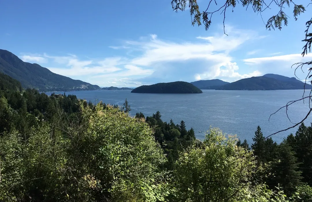
Image Source: AllTrails
Centennial Trail, Lions Bay
Nestled in the charming village of Lions Bay, Centennial Trail offers a coastal forest escape among the easy hikes Vancouver presents within an hour’s drive. Created to commemorate the 100th anniversary of Brunswick Beach joining the Village of Lions Bay in 1999, this historic trail serves as a symbolic connection between communities while providing hikers with spectacular coastal vistas.
Centennial Trail scenic views
The trail’s primary attraction lies in its multiple vantage points overlooking the majestic Howe Sound. As you progress along the path, you’ll encounter several designated lookouts that showcase different perspectives of the water and surrounding mountains. These viewpoints create perfect opportunities for photography or simply taking a moment to appreciate the natural beauty of British Columbia’s coastline.
Arbutus Point stands out as the most impressive viewpoint along the route. This specially designated area features a picnic table where you can rest while enjoying panoramic views across Howe Sound. A thoughtful educational sign identifies the various islands and mountain ranges visible from this vantage point, helping you understand exactly what you’re seeing in the distance.
Throughout your journey, you’ll encounter several educational plaques strategically placed along the trail. These informative signs highlight interesting facts about the local trees, wildlife, and various natural elements you’ll encounter during your hike. Hence, the trail serves both recreational and educational purposes, making it ideal for curious hikers who enjoy learning about their surroundings.
The scenery transitions beautifully as you progress along the trail. Early sections offer stunning sound views across the water, yet the latter portions immerse you in lush coastal forest settings. This variety of landscapes within a single short trail makes Centennial Trail a satisfying experience for nature lovers seeking diversity in their hiking adventures.
Centennial Trail distance and elevation
Centennial Trail presents a manageable challenge appropriate for most fitness levels. The trail measures approximately 2.2 miles (3.5 km) for the complete out-and-back journey. This modest distance means you can complete the entire experience in about 59 minutes to 1.5 hours, depending on your pace and how often you stop to enjoy the views.
In terms of elevation change, the trail involves approximately 328-351 feet (100-107 meters) of total gain. While the path isn’t completely flat, the elevation changes remain gradual enough that the trail earns an “easy” difficulty rating from most hiking resources. First-time hikers, families with children, and those seeking a less strenuous outdoor activity will find this level of challenge quite approachable.
The terrain itself consists primarily of well-maintained paths with some short, steeper sections. Even with these brief inclines, the trail remains accessible for most hikers. Several trailgoers have noted that some portions contain small elevation changes that add interest without becoming overly challenging. This gentle undulation helps make the Centennial Trail experience more engaging than a completely flat path would be.
For planning purposes, the route follows a traditional out-and-back format, meaning you’ll return along the same path you took out. Given these characteristics, Centennial Trail provides excellent value in terms of scenic rewards relative to physical effort—a quality that places it firmly among the best hikes Vancouver offers for those seeking beauty without extreme exertion.
Centennial Trail local tips
To help you navigate the trail successfully, yellow triangle markers appear frequently on trees along the route. These distinctive markers make the path easy to follow even for first-time visitors to the area. Furthermore, the trail begins directly across from the Lions Bay General Store, providing a convenient landmark for locating the trailhead.
Regarding parking, Lions Bay presents some notable challenges. The area has limited parking availability, and visitors should pay careful attention to all posted signs to avoid receiving tickets or having their vehicles towed. Under no circumstances should you park at the Lions Bay General Store despite its proximity to the trailhead—your vehicle will almost certainly be towed if you do. Arriving early, particularly on weekends, represents your best strategy for securing legitimate parking.
Families will appreciate that the trail is kid-friendly, with many visitors describing it as an excellent option for children. The educational signage, manageable distance, and relatively easy terrain make it an ideal introduction to hiking for younger adventurers.
Dog owners should note that Centennial Trail welcomes four-legged companions, provided they remain on leash. The area does have wildlife including bears (multiple hikers have reported bear sightings), underscoring the importance of keeping pets controlled at all times.
The trail remains accessible year-round, with each season offering a different experience. Spring brings wildflowers, summer provides the most reliable weather, fall offers beautiful color changes, and winter transforms the landscape into a serene forest setting. Whenever you choose to visit, the trail delivers a satisfying experience well worth the short drive from Vancouver.
For those seeking to extend their adventure, Centennial Trail connects with other paths in the Lions Bay trail network. You can combine it with trails leading to Crystal Falls or incorporate it into the larger Lions Bay Loop for a more extensive hiking experience. These connections create flexibility in planning your outing based on available time and energy level.
Cascade Falls

Image Source: en.wikipedia.org
Cascade Falls
For a stunning waterfall adventure among Vancouver easy hikes, Cascade Falls stands out as an accessible gem. Located in Mission, approximately 90 minutes from Vancouver, this regional park delivers remarkable scenery with minimal hiking effort, making it ideal for spontaneous weekend escapes.
Cascade Falls trail highlights
The primary attraction at Cascade Falls is undeniably the waterfall itself—a spectacular 30-meter cascade plummeting into an emerald pool below. From the recently installed suspension bridge, you’ll enjoy unparalleled views of the rushing water. This 35-meter long bridge, suspended 20 meters above Cascade Creek, provides the perfect vantage point for appreciating the falls’ full splendor.
Beyond the main waterfall, the area features additional smaller falls, creating a series of cascades that drop another 18 meters through the ravine below the bridge. These tranquil lower pools create picturesque scenes worth capturing.
The viewing experience is enhanced by thoughtfully designed wooden platforms positioned on either side of the suspension bridge. These platforms allow you to safely appreciate the waterfall from multiple angles without risking the steep cliffs and slippery rocks that surround the area.
Cascade Falls distance and elevation
Even among the best hikes Vancouver offers, Cascade Falls stands out for its accessibility:
Total distance: 0.75 km round trip
Elevation gain: Only 40 meters
Average completion time: 30 minutes
The trail begins at a well-maintained parking lot and follows a clearly marked path uphill. After a brief climb, you’ll reach a set of wooden stairs—approximately 50 steps—that lead directly to the suspension bridge and viewing platforms.
For those with mobility concerns, an alternative route exists via a service road that avoids the stairs yet still reaches the falls. This option provides slightly less scenic views along the way, yet ultimately arrives at the same destination.
Cascade Falls family-friendliness
Families searching for easy hikes Vancouver provides will appreciate Cascade Falls’ child-friendly nature. The short distance makes it manageable even for young children. Primarily, parents love that the trail offers significant scenic rewards with minimal walking distance, preventing the inevitable “how much longer?” questions.
Safety features include well-maintained paths and protective railings throughout the viewing areas. Furthermore, the park includes amenities that enhance family visits:
Pit toilets near the parking area
Covered picnic shelter available on a first-come basis
Ample parking space
Year-round accessibility adds to its family appeal, with each season offering a unique experience. Remarkably, winter visits can be particularly magical when portions of the waterfall freeze, creating a dramatically different landscape.
Dog owners should note that while dogs are permitted in the park, they are “highly discouraged” on the suspension bridge due to the metal grips, holes in the surface, and proximity to other visitors.
Conclusion
Vancouver truly offers an abundance of natural escapes right at your doorstep. These five secret hiking spots showcase the remarkable diversity of landscapes you can experience without venturing far from the city.
Each trail delivers its unique rewards—Hunter Trail’s panoramic lake views, Bowen Lookout’s stunning Howe Sound vistas, Pacific Spirit Park’s extensive forest network, Centennial Trail’s coastal perspectives, and Cascade Falls’ magnificent waterfall. Best of all, these adventures require minimal physical exertion while providing maximum scenic payoff.
Most trails featured remain accessible throughout the year, though seasons dramatically transform their character. Summer brings lush greenery and reliable conditions, fall offers spectacular colors, winter creates magical snowy landscapes, and spring awakens with wildflowers and flowing streams.
Additionally, families will appreciate the child-friendly nature of these hikes, with short distances and interesting features keeping young explorers engaged. Dog owners can rejoice as well, since most trails welcome four-legged companions with varying leash requirements.
Before heading out, remember to check current trail conditions, arrive early for parking at popular spots, and pack essentials like water and snacks. Though these trails might be considered “easy,” they still require basic preparation for the most enjoyable experience.
Whether you have just a couple of hours or a full day to spare, these hidden gems prove you don’t need to tackle challenging terrain to experience breathtaking natural beauty around Vancouver. The next time you feel the call of the outdoors but want something manageable, these trails await your discovery just a short drive from the city.